Seychelles

Seychelles2

It is not just a quiet beach destination.  From the ‘smallest’ to the ‘biggest’, ‘oldest’ to the ‘rarest’, Seychelles adds a lot of superlatives to your travel journal.

Think of turquoise water.  Put a million corals as underwater baubles.  Sprinkle silver dust as sand on the shore.  Imagine the swaying palms and a heavy seed, the COCO de MER, as an appetizer.  This seed is a coconut giant, an endemic coconut that takes 6-7yrs to mature and its seed weighs about 18 kg (the world’s largest).  You cannot hold it in your hand —— the largest recorded Coco de Mer weighed 42kg.  Its only natural habitat is the Vallee De Mai palm forest  in Praslin Island, a UNESCO World Heritage Site.  It costs roughly 50,000 Indian Rupees, so one would rather chew gold than drink from this nut.

Whale-shark-Seychelles


Seychelles is a county comprising 115 coralline islands that are considered one of the oldest on earth. ——— There is also a big, fat, brown Aldabra tortoise, the world’s largest land tortoise.  Their home : Aldabra Island, the world’s largest “raised coral atoll” and a UNESCO World Heritage Site.  The biggest and fattest among them all is Esmeralda (it weighs 304kg).


Victoria-Streetscape


It might seem like an “oxymoron”, but all these large, big things live and grow in a small country.  A really small country.  At the last count, Seychelles has 90,000 inhabitants of which 90% live in Mahe —– the largest island.


seychelles_islands_africa_142841


However, nothing beats the “tininess of Victoria”, the capital.  Walk into the world’s smallest capital and before you know where to start sightseeing —— it ends.  You could walk it in 10mins and been-there-seen-it-all in another 15.  An old Church stands like a relic of the colonial age.  A Hindu Temple shimmers in vibrant colours by the arcade.  A cinema resembles a refurbished pigeon-hole.  The monotony broken by Victoria market, where the air is redolent with the whiff of fresh soursop, cassava, mangoes, vegetables, cinnamon, vanilla and a green leaf that carries the aroma of four spices in one.


Odyssey_Boy_and_Coco_de_Mer


The crown jewel is the Big Ben.  The Little Big Ben, actually.  A tiny silver replica of London’s Vauxhall Clock Tower that was erected in the central roundabout to mark Seychelles’ new status as the Crown Colony.


Aldabra giant tortoises


PARADISE is the permanent suffix of this island.  The superlatives —– smallest, largest, biggest, rarest and oldest certainly live here.

———Preeti Verma Lal.

Cinque terre

cinque_terre

Along a beautifully isolated six-mile-stretch of the most seductive corner of the Italian Riviera, lie the CINQUE TERRE small, traffic-free villages gently and steadily carving a good life out of a difficult terrain.  Each fills a ravine with a lazy hive of human activity ——– calloused locals and sunburned travellers enjoying the area’s unique mix of Italian culture and nature.

CINQUE TERRE which means FIVE LANDS, comprise of 5 small coastal villages of RIOMAGGIORE, MANAROLA, CORNIGLIA, VERNAZZA & MONTEROSSO, located in the Italian region of Liguria.  They are listed in the UNESCO World Heritage List.

Cinque_Terre01


All the villages slope down to sea-level, except for CORNIGLIA, which is perched on top of a tall cliff.  All of them possess an old-world-charm (from north to south : Vernazza, Corniglia, Manarola and Riomaggiore).  The northernmost one ——- Monterosso is completely different.  It is beach resort type, with not much to see beyond the boardwalk, apart from modern apartment blocks and hotels ———— nothing like the narrow, crooked streets of the other four villages, lined with colourful old houses stacked haphazardly on top of each other.


49411_1600x1200-wallpaper-cb1330957507


RIOMAGGIORE is the southernmost of the Cinque Terre.  During the , you can hear the bell towers chiming and at night the frogs are in frenetic chatter as small boats go night-fishing for anchovies and other fish using lights to attract the fish.  There is also an ancient stone CASTELLO about which little has been written.  An information sign, outside, explains that first mention of the CASTELLO appeared in a document from the mid 500s, which already described it as “ancient.”  Its quadrangular walls with two circular towers were built to protect the citizens, in case of an attack from the sea.  In 800, the CASTELLO became a cemetery and parts were destroyed to adapt it to its new function.  Now, there is an assortment of cafes, bars, restaurants and, of course, GELATERIE.  There are also shops selling the typical yummy Italian fair: fresh fruit (strawberries, cherries and nespole), an assortment of SALUMI (salami and mortadella), cheeses and olives.  These are good places to stock up for the hikes into the hills, although all of them are not very far away.

MANAROLA is a place filled with boats —- covered boats of all kinds line the main street.  There are many lovely places to eat and drink.  There is also a nice little swimming area —- a little cement pier next to some big rocks that you can wade out from into the blue, blue waters.

Streets-of-Monterosso-Cinque-Terre-Liguria-Italy


CORNIGLIA : At the station, the path gains height to reach the town.  The road passes lemon trees, vines, lilies and vegetation of all kinds and, in May, the air is full of the perfume of flowers.  Corniglia feels smaller and quieter, but it is just as “quaint” as the other four.  As Corniglia is atop a large hill, it is only reachable from the train station by either climbing 365 steps up the hill (one step for each day of the year), or there is a bus, run by the Cinque Terre National Park, that takes people up to Corniglia and back down again.

VERNAZZA :  The Blue Trail from Corniglia to Vernazza is a dirt path that starts off in an olive grove.  It keeps climbing and things get a bit sweaty and steep in some places with many stone steps and a few switchbacks.  The place, itself, has a maze of tiny streets that eventually lead down to the main street.  Vernazza is lively and boisterous and has a great scene ——- two clock towers, a beach, boats and a large public space with umbrellas and tables, where you can spend the evenings having wine and watching the mountainous coastline zigzag in and out, hiding Monterosso.

riomaggioreNew


MONTEROSSO is built to accommodate many tourists in large modern apartments and hotels.  Walking is very popular.  In order to walk along the trails between the villages, one must purchase a pass from information offices near the train stations at any of the 5 villages.  It costs 5 euros for an adult or 10 euros to get unlimited travel on trains between the villages.  The pass also allows you to use buses within Cinque Terre.

The main attraction of Cinque Terre is the landscape.  Mediterranean herbs and trees grow spontaneously from the top of the hills down to the water level.  It has been estimated to have taken about 200yrs to build the entire “stone-wall-network”.
Depending on the time of the year, there are some specific things to see :  ** The Lighted Nativity in Manarola (Dec. 8 till late Jan).  It is the world’s biggest Lighted Nativity.  ** The Patron Festivity of the five villages : (all between late May & August), a mix of religious ceremony and popular parties.  ** The Pirates Attack in Vernazza (mid summer), a celebration of the successful defence from a Saracen attack which occurred during the middle ages.  ** The Harvest (early / mid September) and Wine Making, when men’s shoulders and women’s heads are still used as they were 100s of years ago.  ** The Sea Storms (frequent in winter), a great show of Nature’s power.

corniglia_san_pietro


Cinque Terre is famous for the dry white wine ——– simply called CINQUE TERRE and the SCIACCHETRA ( a prized dessert wine, made from prime grapes dried to the point of holding only a few drops of sweet juice).  A colourful addition to the Cinque Terre products is LIMONCINO (a dessert wine made from steeping lemon peels in pure alcohol and then adding sugar and water to make a fragrant and fresh liquor.  The lemons, another famous product of Cinque Terre, are prominently on display in many LIMONETI (lemon groves) and at the annual Lemon Festival held each year in Monterosso during the season of Pentacost.  The “grape-routes” are still as they once were with fig trees planted in strategic positions to give shade during breaks from work, agaves planted to mark boundaries, to line the footpaths along steep, stony steps and to indicate the rail terminals of the recently installed memorials which are the only vertical structures emerging from this seemingly completely horizontal landscape.  The large wicker baskets of grapes (CORBE) are arranged along the POSE (little walls as wide as tables, built solely for this purpose).  The Cinque Terre grape tracks reach down to the sea.  In the past, small fishing boats, called GOZZI, stood immediately below the terraced vineyards.  Baskets, laden with grapes, were then lowered from above into these small boats which then sailed around to the otherwise inaccessible villages.  Nowadays, this method is nothing but a distant memory, but, by visiting Cinque Terre you are still able to sample some of the prized wines of the world that have been created by centuries of backbreaking experience.

Rick Steve says, “There’s not a Fiat in sight ——- just sun, sea, sand (well pebbles), wine and “pure, unadulterated Italy.”  Enjoy the villages, swimming and hiking and the evening romance of one of God’s great gifts to Tourism.  While the Cinque Terre is now discovered (and can be unpleasantly crowded at midday, when tourist boats and cruise ship excursions drop by), I’ve never seen happier, more relaxed tourists.”

Rapa Nui National Park

RAPA NUI is the indigenous name of EASTER ISLAND, and it bears witness to a unique cultural phenomenon. A society of Polynesian origin, that settled there in 300AD, established a powerful, imaginative and original tradition of monumental sculpture and architecture, free from external influence.  From the 10th-16th century, this society built shrines and erected enormous stone figures known as MOIA, which created an unrivaled cultural landscape that continues to fascinate people throughout the world.

easter-island


RAPA NUI National Park is a protected Chilean wildlife area located in Easter Island, which concentrates the legacy of the Rapa Nui Culture.  Easter Island, the “most remote inhabited island on the planet”, is 3,70km from the coast of Chile and has an area of 16,628 hectares, while the World Heritage Property occupies an area of approximately 7,000 hectares, including 4 nearby islets.


Easter Island Statues


The island was colonized towards the end of the 1st millennium of the Christian era, by a small group of settlers from Eastern Polynesia, whose culture manifested itself between the 11th and 17th centuries, in great works such as the AHU (ceremonial platforms) and carved MOAI (colossal statues) representing ancestors.  Rapa Nui National Park’s most prominent attributes are the archaeological sites.  It is estimated that there are about 900 statues, more than 300 ceremonial platforms and 1000s of structures related to agriculture, funeral rites, housing and production and other types of activities.  Prominent among the archaeological pieces are the MOAI that range in height from 2m-20m, and are for the most part carved from the yellow-brown lava tuff, using simple picks (TOKI) made from hard basalt and then lowered down the slopes into previously dug holes.

There are many kinds of them and of different sizes : those in the process of being carved, those in the process of being moved to their final destinations i.e. the AHU those being torn down and erected.  The quarries are invaluable evidence of the process of their carving.  There are certain constant features, notably a raised rectangular platform of large stones filled with rubble, a ramp often paved with rounded beach pebbles and a levelled area in front of the platform.

Easter.Island.original.3957


Also extremely valuable are the rock-art sites, which include a large variety of styles, techniques and motifs.  There is also a village of a ceremonial nature named ORONGO which stands out because of its location and architecture.  The structures are of great interest.  According to some studies, the depletion of natural resources had brought about an ecological crisis and the decline of the ancient RPA NUI society by the 16th century, which led to the decline and to the spiritual transformation in which these megalithic monuments were destroyed.  The original cult of the ancestors was replaced by the cult of the “man-bird”, which has an exceptional testimony ——– the ceremonial village of ORONGO.  54 semi-subterranean stone houses of “elliptical floor plans” complement this sacred place, profusely decorated with petroglyphs alluding to both the “man-bird” & “fertility”.  This cult saw its end in the middle of the 19th century.


Crater of Rano Kau, Easter Island, Chile


Colonization, the introduction of livestock, the confinement of the original inhabitants to smaller areas, the dramatic effect of foreign diseases and, above all, slavery reduced the population of RAPA NUI, as well as immigrants from diverse backgrounds accounting for a significant mixed population.

Rapa Nui National Park is a testimony to the undeniably unique character of a culture that suffered a debacle, as a result of an ecological crisis followed by irruption(sudden increase) from the outside world.  The substantial remains of this culture blend with their natural surroundings to create an “unparalleled cultural landscape”.

Rapa-Nui-National-Park-1


The Rapa Nui National Park covers approximately 40% of the island and incorporates an ensemble of sites that is highly representative of the totality of the archaeological sites and of the most outstanding manifestations of their numerous typologies.  The management and conservation efforts, still insufficient, focus on addressing anthropic factors and the effects of weathering both on the material ———- volcanic lava and tuff ———- and on the stability of structures.  Progress has been made in the closure of areas, monitoring and the layout of roads, so as to maintain the “visual integrity” of the landscape.


easterisland4


The entire island was declared a NATIONAL MONUMENT in 1935, and the same was done with the islets adjacent to Easter Island in 1976.  The essential requirement for the protection and management of this property lies in the multi-faceted statues as a World Heritage Site, as a reference point and basis for the development of the population of the island and repository of answers to fundamental questions that are far from being revealed.  On 22nd of March, 1996, UNESCO designated it a World Heritage Site.

Masroor rock-cut temple

Masroor_rock-cut_temple_and_adjoining_water_tank

Kangra is the most populous district of Himachal Pradesh, India.  Dharamshala is the administrative headquarters of the district.  It is also home to the MASROOR ROCK-CUT TEMPLE, also known as HIMALAYAN PYRAMID, and WONDER OF THE WORLD for being a likely contender for the UNESCO World Heritage Site (said to be India’s 1st Heritage Village)

master-peice-at-masroor-temple


Within the MASROOR ROCK-CUT TEMPLE complex there are 15 rock-cut temple in Indo-Aryan style and are richly carved.  It is a unique  “monolithic” structure in the sub-Himalayan region.

Main_courtyard_at_Masroor_rock-cut_temple


The main shrine contains 3 stone images of Rama, Lakshman and Sita, but the presence of the figure of Shiva in the centre of the lintel affords a strong presumption that the Temple was originally dedicated to MAHADEVA.  The Temple complex is located on a 2,500ft high hill., and also has a large rectangular water pond.  The Temple complex is believed to have been built by the Pandavas during their exile and the exact date is not known.  As per records, the ancient name of the city of Kangra was BHIMNAGAR (founded by Bhima), one of the Pandava Brothers.

ROCK_CUT_TEMPLES,_MASROOR


It is important to discuss the “rock-cut” technique and the place this temple complex occupies among the rock-hewn monuments in India.  The “rock-cut” style started in the reign of the Pallava King, Narsingha Varman (630-668 AD) during the 1st half of the 7th century.  It reached its climax in the Kailasha Temple at Ellora.  Though “rock-cut” caves are common in South India, yet, temples cut out of “free-standing rocks”, known to archaeologists and art critics, are only 4 in number ———- RATHAS of MAMMALAPURAM, KAILASHAS at ELLORA, Temple complex at MASROOR and the DHARMNATHA Temple at DHARMNAR.  The RATHAS & KAILASHAS are built in the DRAVIDIAN style, whereas the MASROOR & DHARMNAR ones are in the NAGARA style.  MASROOR beats its NAGARA rival (DHARMNATHA) in situation, size and execution.  The MASROOR complex has 15 Temples, whereas DHARMNATHA has only 8.

Masroor2


At MASROOR, the temples are not separate, but surround a central shrine, whereas in DHARMNATHA, the smaller temples are entirely separate from the main one.  Carvings and ornamentation, at MASROOR, are of a much superior order than at DHARMNATHA and the length of the latter is half that of the former.

Masroor rock cut temple


The DHARMNATHA group has been built in a pit-like hollow, whereas the MASROOR group is on top of a 2,500ft high hill range.  ONE LOOKS BELOW & THE OTHER LOOKS UP.  ONE DEPRESSES & THE OTHER ELATES.——-ROCK-CUT style is  much more difficult than the “structural” one.  In “structural”, the artist shapes the material as he likes, whereas in “rock-cut” the material determines the way the artist should move.  The limitation makes an artist’s creation, out of a rock, a most difficult task, and the ability with which the remote artist of the 7th and 8th centuries carried out their purpose is “superhuman”.

20101230-img_0929


Although the remote location of these Temples protected them from the invading army of Mahmud Ghazni, and their stone construction prevented severe damage in the 1905 earthquake.

Diocletian’s palace

Interior_of_Diocletian's_Palace,_Split,_Croatia

DIOCLETIAN’S PALACE is an ancient palace built by the Roman Emperor DIOCLETIAN at the turn of the 4th century on the bay of ASPALATHOS, and it today forms the centre of the city of SPLIT.
While it is referred to as a “palace”, because of its intended use as the retirement residence of Diocletian, the term can be misleading as the structure s massive and more resembles a “large fortress” : about half of it was for Diocletian’s personal use and the rest housed the military garrison.

Inside-Diocletians-Palace


Diocletian built the massive palace in preparation for his retirement on the 1st of May, 305 AD.  It lies in a bay on the south side of a short peninsula running out from the Dalmatian coast, 4mls from Salona, the capital of the Roman province of Dalmatia.  The terrain slopes gently seaward and is typical “karst” consisting of low limestone ridges running east to west with “marl” in the clefts between them.

2009_10_20_croatia_split_diocletian_palace_113_model_use_this


After the Romans abandoned the site, the Palace remained empty for several centuries.  In the 7th century, nearby residents fled to the walled Palace in an effort to escape invading Slavs.  Since then the Palace has been occupied, with residents making their homes and businesses within the Palace basement and directly in its walls.  Today, many restaurants and shops and some homes can still be found within the walls.
After the Middle Ages, the Palace was virtually unknown in the West, until the Scottish neo-classical architect Robert Adam had the ruins surveyed and, with the aid of French artist and antiquary Charles-Louis Clerisseau and several draughtsmen published “Ruins of the Palace of the Emperor Diocletian at Spalatro in Dalmatia”.

Porta_aurea,_northern_gate_of_Diocletian's_Palace,_Split


Diocletian’s Palace was an inspiration for Adam’s new style of “neo-classical” architecture and the publication of measured drawings brought it into the “design vocabulary” of European architecture for the first time.  A few decades later,, in 1782, the French painter Louis-Francois Cassas created drawings of the Palace, published by Joseph Lavallee in 1802 in the chronicles of his voyages.
This Palace is today, with all the most important historical buildings, in the centre of the city of Split.  Diocletian’s Palace far transcends local importance, because of its degree of preservation.  The Palace is one of the most famous and complete architectural and cultural features of the Adriatic coast.  As the “world’s most complete remains of a Roman Palace”, it holds an outstanding place in Mediterranean, European and World Heritage.

OLYMPUS DIGITAL CAMERA


In November 1979, UNESCO, in line with the international convention on cultural and natural heritage, adopted a proposal that the historic city of Split, built around the Palace, should be included in the register of World Cultural Heritage.  In November 2006, the City Council decided to permit over 20 new buildings within the palace (including a shopping and garage complex), despite the fact that the Palace had been declared a UNESCO World Heritage Monument.  It is said that the decision was politically motivated and largely due to lobbying by local property developers.  Once, the public in 2007 became aware of the project, they petitioned against the decision and won.  No new buildings, shopping centres or the underground garage was built.

diocletian_palace_underground


The World Monuments Fund has been working on a conservation project at the Palace, including surveying structural integrity and cleaning and restoring the stone and plasterwork.  The Palace is depicted on the reverse of the Croatian 500 kuna bank note, issued in 1993.
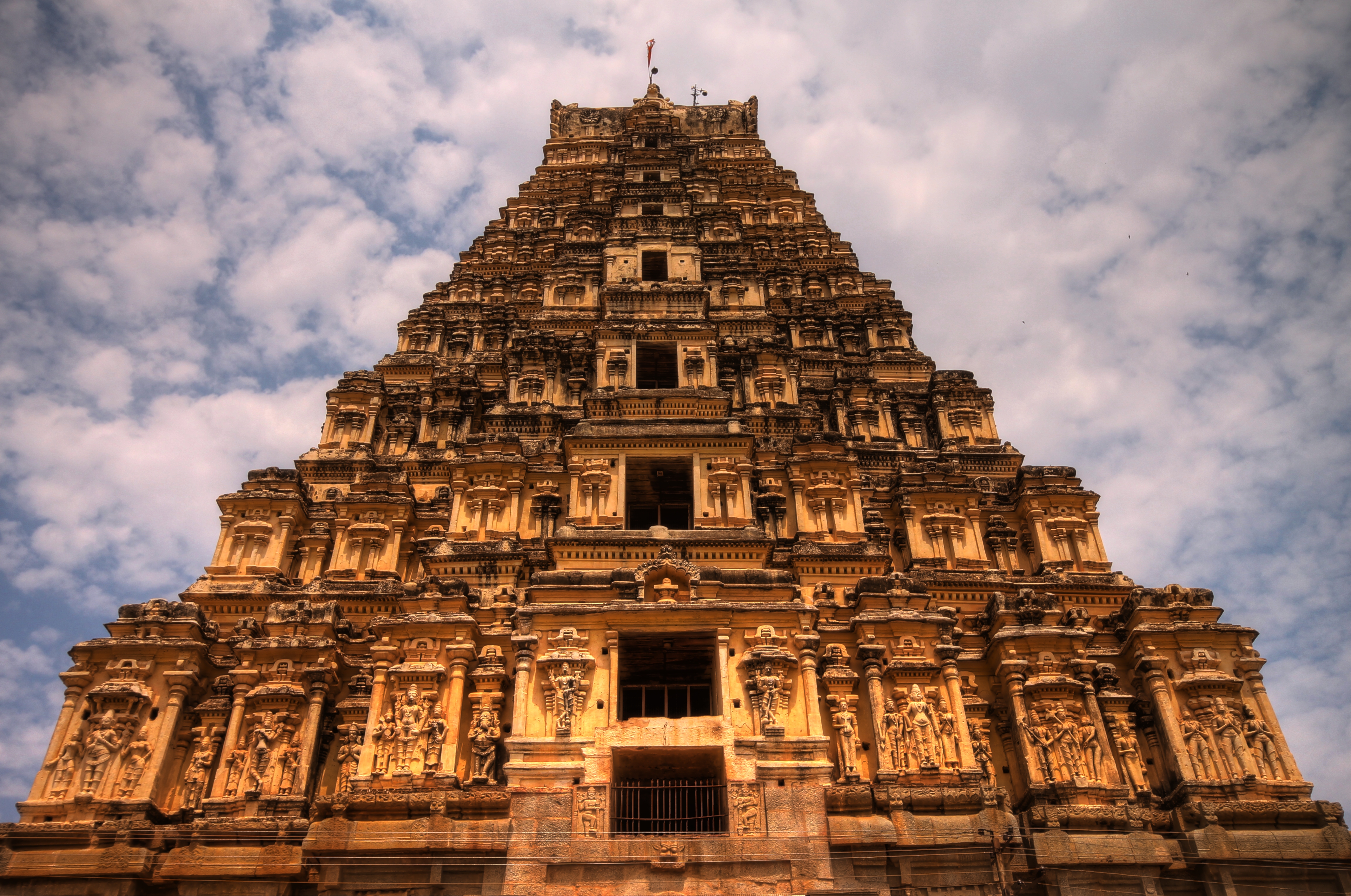
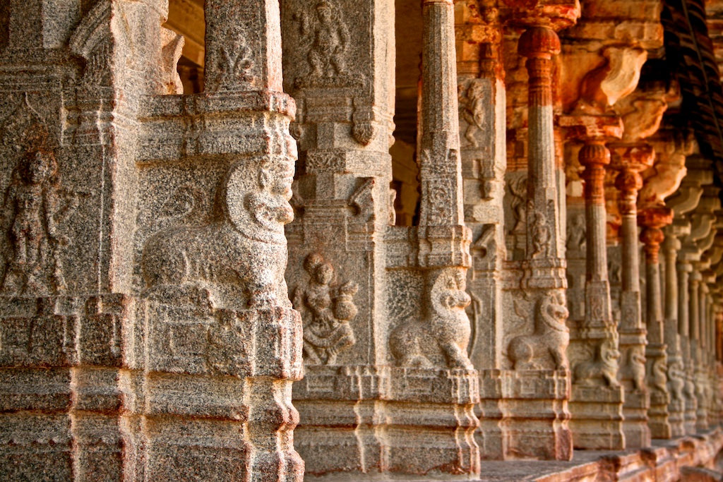
The ground plan of the Palace is an irregular rectangle (approx. 160m by 190m) with towers projecting from the western, northern and eastern facades.  It combines qualities of a luxurious villa with those of a military camp, with its hue gates and watch-towers.  The Palace is enclosed by walls, and at times, it housed over 9,000 people.  Subterranean portions of the Palace feature “barrel-vaulted” stonework.

Diocletian's_Palace_south_facade,_night_1


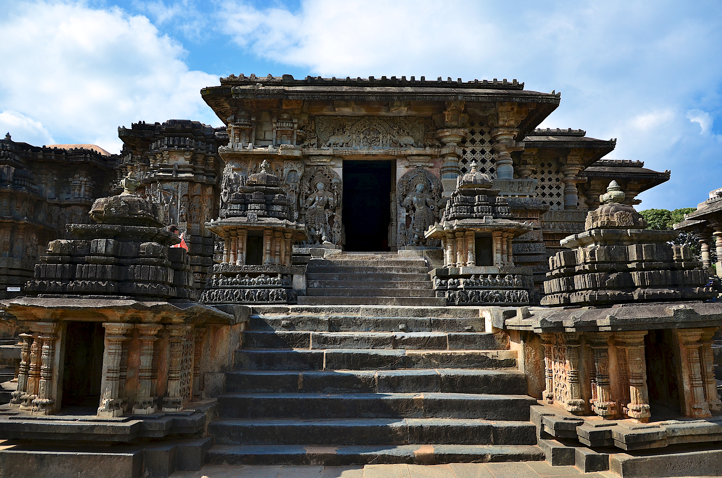
Only the southern façade which rose directly from, or very near to, the sea, was “unfortified”.  The elaborate architectural composition of the “arcaded gallery” on its upper floor, differs from the more severe treatment of the 3 “shore facades”.  A monumental gate in the middle of each of these walls led to an enclosed courtyard.  The southern sea-gate (the PORTA AENEA) was simpler in shape and dimensions than the other 3, and it is though, that it was originally intended either as the Emperor’s private access to the sea, or as service entrance for supplies.
The design is derived from both “villa” and “castrum” types, and this duality is  also evident in the arrangement of the interior.  The transverse road (decumanus) linking the eastern gate (the SILVER GATE or PORTA ARGENTEA) and western gate (the IRON GATE or PORTA FERREA) divided the complex into two halves.  In the southern half were the more luxurious structures —- i.e. the Emperor’s apartments, both public and private and religious buildings.
The Emperor’s apartments formed a block along the sea front and were situated above a sub-structure, because the sloping terrain demanded significant differences in level.  Although for many centuries almost completely filled with refuse, most of the sub-structure is well-preserved and indicates the original shape and disposition of the rooms above.

Depositphotos_25842487_m_fixed


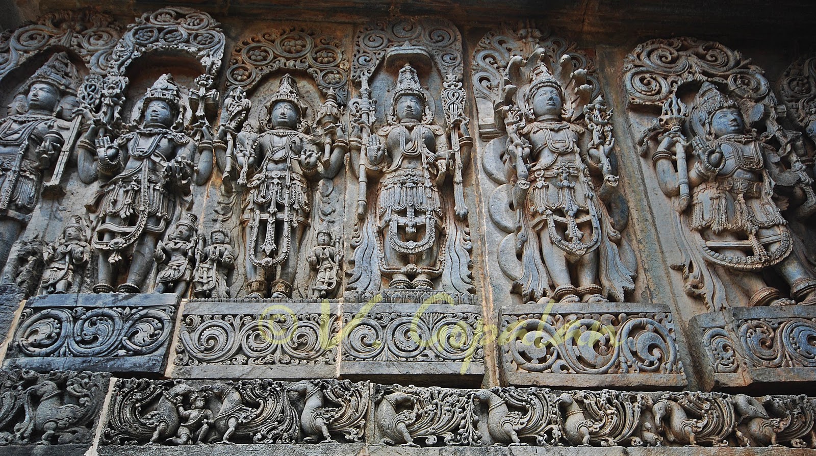
A monumental court, called the PERISTYLE, formed the northern access to the Imperial apartments.  It also gave access to Diocletian’s mausoleum on the east (now Cathedral of Saint Dominus) and to 3 Temples on the west (2 of which are now lost, the 3rd having become a baptistery, originally being the Temple of Jupiter).  There is a Temple just to the west of PERISTYLUM called the Temple of Aesculapius, which has a semi-cylindrical roof made out of hand-carved stone blocks which did not leak until the 1940s, and was then covered with a lead roof.  The Temple was restored recently.
The northern half of the Palace, divided into 2 parts by the main north-south street leading from the Golden Gate (PORTA AUREA) to the PERISTYLE, is less well-preserved.  It is usually supposed that each part was a residential complex, housing soldiers, servants and, possibly, some other facilities.  Both parts were apparently surrounded by streets.  Leading to perimeter walls there were rectangular buildings, possibly storage units.
The Palace is build of white local limestone and marble of high quality, most of which was from BRAC marble quarries on the island of BRAC, of “tuff” taken from nearby river beds and brick made in Salonitan and other factories.  Some material for decoration was imported Egyptian granite columns, fine marble for revetments and some capitals produced in workshops in the PROCONNESOS.  The Palace was decorated with numerous 3,500-year-old granite SPHINXES, originating from the site of Egyptian Pharaoh THUTMOSE -3.  Only 3 have survived the centuries.  One is still located on the PERISTYLE, the 2nd sits “headless” in front of Jupiter’s temple and a 3rd is in the city museum.

Split


Water for the Palace and the whole of Split area comes from the JADRO RIVER near SALONA.  Along the road from Split to Salona, impressive remains of the original Roman aqua-duct can still be seen.  They were extensively restored in the 19th century.  Today, the Palace, along with adjoining areas to the west, forms the very heart of Split.  Many shops, restaurants, bars and apartments for tourists can be found within the Palace.
DIOCLETIAN’S PALACE is being used as a location for filming the 4th season of the HBO series ——- GAME OF THRONES.   

Svetitskhoveli Cathedral

Svetitskhoveli Cathedral

SVETITSKHOVELI CATHEDRAL, in Georgian literally means the LIVING PILLAR CATHEDRAL.  In Georgian “sveti” means “pillar” and tskhoveli” means “life-giving” or “living”, hence the name SVETITSKHOVELI.  This is an Orthodox Cathedral located in the historical town of MTSKHETA, Georgia, 20km north-west of the nation’s capital TBILISI.

svetitskhoveli-cathedral


SVETITSKHOVELI CATHEDRAL, known as the burial site of Christ’s Robe has long been the principal Georgian Church and remains one of the most venerated places of worship to this day.  It presently functions as the seat of the Archbishop of MTSKHETA & TBILISI, who is at the same time Catholicos-Patriarch of All Georgia.

Svetitskhoveli Cathedral1


The current Cathedral was built in the 11th century by the architect Arsukidze,, though the site itself is older dating back to the early 4th century and is surrounded by a number of legends associated, primarily, with the early Christian traditions.  It is the 2nd largest Church building in the country, after the recently consecrated —— Holy Trinity Cathedral of TBILIS, and is listed as an UNESCO World Heritage Site along with historical monuments of MSKHETA.

1. Svetitskhoveli Cathedral, Mtshekta, Georgia


The original Church was built in the 4th century AD during the reign of Mirian -3 of Kartli (Iberia).  Saint Nino is said to have chosen the confluence of the Mount Kvari and Aragvi rivers as the place of the 1st Gregorian Church.  According to Georgian “hagiography”, in the 1st century AD, a Georgian Jew —- Elias was in Jerusalem when Jesus was crucified.  He bought Jesus’ Robe from a Roman soldier (it was a seamless one) at Golgotha (also known as the “place of the skull”) and brought it back to Georgia.  Returning to his native city, he was met by his sister Sidonia, who, upon touching the Robe, immediately died from the emotions engendered by the Sacred Robe, which could not be removed from her grasp and so she was buried with it.

Svetitskhoveli-Cathedral-6


The place where she was buried, with Christ’s Robe is preserved in the Cathedral.  Later, from her grave grew an enormous cedar tree.  Ordering the cedar tree chopped down to build the Church, Saint Nino had 7 columns made from it for the Church’s foundation.  The 7th column, however, had magical properties and rose by itself into the air.  It returned to earth after Saint Nino prayed the whole night.  It was further said that from the 7th column a sacred liquid flowed and cured people of various diseases.

restored-fresco-in-svetitskhoveli-cathedral


SVETITSKHOVELI CATHEDRAL, portraying this event can be seen on the 2nd column on the right-hand from the entrance.  Reproduced widely throughout Georgia, it shows Sidonia with an angel lifting the column in Heaven.  Saint Nino is in the foreground : King Mirian and his wife Queen Nana are to his right and left.  Georgia, officially adopted Christianity as its state religion in 317.

Georgia Svetitskhoveli Cathedral Zodiac


SVETITSKHOVELI CATHEDRAL has been damaged several times during history, notably by the invasion of Persians and Timur.  It has also been damaged by earthquake.  During the restoration of 1970-71, the base of the Basilica was built.  During the early years of Gregorian Church building, the Basilica was the dominant type of the Gregorian Church architecture, before the “cross-dome” style emerged.

Svetitskhoveli Cathedral inside


In the 11th century, the present SVETITSKHOVELI CATHEDRAL was rebuilt (from 1010-1029) in the “cross-dome” style by Arsukidze.  The Cathedral is surrounded by a defensive wall, built of stone and brick during the reign of King Heraclius in 1787.  The top storey was designed for military purposes and has gun emplacements.  The entrance to the cathedral, from the wall, is located to the south.  The wall has 8 towers : 6 of them “cylindrical” and 2 of them “square”.  Archaeological expedition in 1963, found the house of the Patriarch of the 11th century at the southern part of the wall.  Inside the churchyard, the remains of the 2-storey castle of Patriarch Anton —- 2 were found.

Svetitskhoveli Cathedral top


The base of the 3-storey Church, is supposed to have been built by Vakhtang Gorgasali after Saint Nino’s original Church has been found by archaeologists during the restoration of 1970-71.  The architecture of the present Cathedral, which dates from around 1020, is based on the “cross-dome” style.  The characteristics of the style is that the “dome” is placed across all four sides of the Church.  The structure of the Church is intended to ensure “good acoustics”.  The dome of SVETITSKHOVELI was re-constructed several times over the centuries to keep the Church in good condition.

1287074308-svetitskhoveli-cathedral-and-mass--tbilisi_474611


The basic stone used for the Cathedral is a “sandy yellow” with trimmings, while around the apse window a red stone was used.  The green stone used in the drum of the cupola is from the 17th century.  The “curved blind” arcading throughout is “unaltered” from the 11th century.  A large window occupies most of the western side of the Church.  The decorations show Christ sitting between two angels.  The original sculpture, on the external wall, has not survived, but was restored several times, most recently in the 19th century.

TWSvetitskhoveli5Fresco


The interior walls are painted with frescoes, most of which have not survived in their original state.  The decorations on the Church’s stonework features ” carved grapes”, reflecting the country’s ancient wine-making tradition.  On the south side, there is a small stone Church built into the Cathedral.  This is a symbolic copy of the Chapel of the Holy Sepulchre in Jerusalem.  It was built between the end of the 13th and the beginning of the 14th centuries, and it was erected here to mark SVETITSKHOVELI as the 2nd most sacred place in the world (after the church of Jerusalem), thanks to Christ’s Robe.  Remains of the original “life-giving” or “living” pillar are also here.

Svetitskhoveli Cathedral inside


The cathedral was not only the site of the coronation of the Georgian Kings, but also served as their burial place.  Ten of the Kings are known to have been buried here, although only 6 tombs have been found, all in front of the altar.

Svetitskhoveli Cathedral long view


A 2010 UNESCO report has found that structural issues threaten the overall stability of the cathedral.

The architecture of Hoysala

Hoysala temple architecture

The modern interest in the Hoysalas is due to their patronage of art and architecture rather than their military conquests.
The brisk temple building throughout the kingdom was accomplished, despite constant threats from the Pandyas to the south and the Seunas Yadavas to the north  Their architectural style, an offshoot of the western Chalukya style, shows distinct Dravidian influences.  The Hoysala Architecture Style is described as KARNATA DRAVIDA as distinguished from the traditional, with many unique features.

Hoysala temple architecture


A feature of Hoysala Temple Architecture, is its attention to exquisite detail and skilled craftsmanship.  The tower over the temple shrine (vimana) is delicately finished with intricate carvings, showing attention to the ornate and elaborately detailed rather than to a tower form and height.  The “stellate” design of the base of the shrine with its rhythmic projections and recesses is carried through the tower in an orderly succession of “decorated tiers”.
Hoysala Temple Sculpture replicates this emphasis on feminine beauty, grace and physique.  The Hoysala artists achieved this with the use of “soapstone” (chloritic schist), a soft stone, as base building and sculpture material.
Other standard features in a Hoysala Temple are the large domed-roofs over the towers, which is also the largest sculptural piece called the HELMET or AMALAKA and whose shape usually follows that of the shrine (square or star-shape), the KALASA (decorative pot at the apex of the dome) and the Hoysala Crest (emblem of a Hoysala warrior stabbing a lion) over the SUKHANASI (the nose).

Hoysala royal emblem


The CHENNAKESAVA TEMPLE at Belur and the HOYSALESWARA TEMPLE at Halebidu are the best known, because of the beauty of their sculptures, the Hoysals art finds more complete expression in the smaller and lesser known temples.  The outer walls of all these temples contain an intricate array of stone sculptures and horizontal “friezes” (decorative mouldings) that depict the Hindu Epics.  These depictions are generally “clockwise” in the traditional direction of circumambulation (pradakshina).  The Temple at Halebidu has been described as an outstanding example of Hindu architecture and an important milestone in Indian architecture.  The Temples of Belur and Halebidu are a proposed UNESCO World Heritage Sites.

THE CHENNAKESAVA TEMPLE at Belur


Hoysala temple architecture


Hoysala temple architecture


CHENNAKESAVA TEMPLE at Belur


The main attraction here is the Chennakesava Temple Complex, which contains the Chennakesava Temple (dedicated to Chennakesava, meaning “Handsome Vishnu” ) as the centre-piece, surrounded by the KAPPE CHENNIGRAYA TEMPLE, built by Shantala Devi, Queen of King Vishnuvardhana.  There are two more shrines here that are still in use by devotes and there is a PUSHKARNI or STEPPED WELL to the right side of the main entrance.  The Dravida style RAYAGOPURAM, at the entrance which was a later addition by the Vijayanagar kings, who considered this deity as one of their KULADEVATA or FAMILY GOD.  The Temple was built by Vishnuvardhana in commemoration of his victory over the Cholas at Talakad in 1117 CE.  Legend has it that it took 103 years to complete and Vishnuvardhana’s grandson —– Veera Bllala –2 completed the task.  The façade of the Temple is filled with intricate sculptures and friezes, episodes from the Indian Mythological Epics and sensuous dancers (SHILABALIKAS).  Inside the Temple are a number of ornate pillars.  DARPANA SUNDARI (Lady with the mirror), carved on the wall of the Belur Temple is one of the major attractions in the complex.

THE HOYSALESWARA TEMPLE at Halebidu


Hoysala temple architecture


Hoysala temple architecture


Hoysala temple architecture


The Temple complex comprises 2 Hindu Temples and 2 Jain Basadi  In front of these temples there is a large lake.  The 2 Nandi images, on the sides of the Hoysaleswara Temple, are “monoliths” ; soapstone (chloritic schist) was used for the construction of these temples.  There is an Archaeological Museum in the Temple complex.  The HOYSALESWARA TEMPLE, dating back to  1121 CE, is astounding for its wealth of sculptural details.  The walls of the Temple are covered with an endless variety of depictions from Hindu Mythology, animals, birds and shilabalikas. (dancing figures).  Yet, no two sculptures, of the Temple, are the same.  This magnificent temple, guarded by a Nandi Bull, was never completed, despite 86 years of labour.  The Jain Basadi, nearby, are equally rich in sculptured details.

THE SOMANATHAPURA TEMPLE


SOMANATHAPURA TEMPLE


SOMANATHAPURA TEMPLE


SOMANATHAPURA TEMPLE


Situated in the unobtrusive village of Sommanathapur, 35km from Mysuru, the exquisitely carved “star-shaped” temple with “triple towers” is a perfect example of Hoysala Architecture.  The friezes, on its outer walls, with their intricately carved rows of caparisoned elephants, charging horsemen and mythological birds and beasts will leave you spellbound.  Beautifully sculptured  images of gods and goddesses and scenes from the Epics, as well as the remarkable ornate ceilings in  the pillared hall will take your breath away.

THE BRAHMESHVARA TEMPLE – Kikkeri in Mandya District


Brahmeshvara_Temple


Brahmeshvara_Temple_


Brahmeshvara_Temple_

The design of the Temple is “unique”.  The interior of the Temple has been widened beyond its base, by making the outer walls bulge out in a “convex shape”.  This is a EKAKUTA (single shrine) construction.  There is a 4ft tall image of Shiva in one of the niches of the NAVARANGA (hall).  The MADANIKA figures (also called SALABHNJIKA, refers to the sculpture of a woman, displaying stylized feminine features) carved on the capital of the pillars of the hall, are works of fine art.  The VIMANA (shrine that contains the cella) has a well executed, highly decorative and intact tower (SHIKHARA).  The vestibule ( called ANTARALA) which connects the cella to the hall has a SUKHANASI (called “nose’ ) which is actually a low protrusion of the tower over the shrine that is built over the vestibule.  The large wall images of deities and their attendants are placed below the decorative towers (the AEDICULAS) on PILASTERS.  Below these images is the base of the wall which comprises five different horizontal mouldings, one of which is a row of blocks.
About 100 Temples have survive in present-day Karnataka State, mostly in the Malnad (hill) districts, the native home of the Hoysala Kings.  As popular tourist destinations in Karnataka, Hoysala Temples offer an opportunity for pilgrims and students of architecture to examine medieval Hindu Architecture in the KARNATA DRAVIDA tradition.

Inaccessible Island

Inaccessible Island

INACCESSIBLE ISLAND is 14 sq.kms in area, rising out of the South Atlantic Ocean, 28 miles south-west of Tristan da Cunha, is an extinct volcano (last active 6 million years ago).  It is part of the Archipelago of Tristan da Cunha which is part of the overseas territory of the UK known as Saint Helena, Ascension and Tristan da Cunha.  Along with Gough Island, Inaccessible Island is a protected wildlife reserve and both make up the UNESCO WORLD HERITAGE SITE of Gough and Inaccessible Island.
Inaccessible Island was discovered in January 1956 during a voyage by a Dutch ship under the command of Jan Jacobszoon, 146 years after Tristan da Cunha was 1st sighted by Portuguese sailors.  Jacobszoon originally named it “NACHTGLAS” Island.
There are 2 explanations for the name “Inaccessible” Island.  One is that on maps, the newly-found island was referred to as “Inaccessible”, because the Dutch crew who landed were not able to get further inland than the beach., as they were blocked by 1000-ft high cliffs.  The other claims that the French Captain d’Etcheverry renamed the island in 1778 after not being able to land.  In 1803, US sailors, led by Amasa Delano, made landfall on the island.

Inaccessible_near_aborted_landing_(c)_oex


In 1816, Corporal William Glass and his family settled on the island and they brought domestic animals with them.  Then, the Stoltenhoff brothers, who arrived on Inaccessible Island, from Germany in 1871, lived there for several years intending to make a living, sealing ad selling their wares to passing traders (forgetting how infrequently Inaccessible had visitors).  However, due to scarcity of food, they were “overjoyed” to be rescued in 1873 during HMS Challenger’s visit to examine the flora and fauna there.  The nearby Stoltenhoff Island is named after the brothers.

Northern_Rockhopper_Penguin_on_Inaccessible_Island


In 1922, the Norwegian Scientific Expedition spent 3 weeks on the island, during which time they managed to gain access to the plateau and extensively catalogued plants, birds and rocks. Another attempt was made during the Royal Society’s expedition of 1962 to Tristan da Cunha, which took scientists to Inaccessible Island.  Like many other explorers before them the scientists before them were not able to reach the interior of the island.
In a 1982 expedition (16/10/1982 — 10/02/1983) students and faculty of Denstone College made detailed maps of the island, studied its flora, fauna and geology and carried out a marking programme on more 3,000 birds.
inaccessible Island-mapIn 1997, Inaccessible Island’s territorial waters, out to 22km, were declared a nature reserve under the Tristan da Cunha Conservation Ordinance of 1976.  Currently, only guides from Tristan are allowed to take visiting cruise ships to Inaccessible Island, and most trips to the island are now made at the request of expatriates.
No land mammals, reptiles, amphibians, butterflies or snails have recently been found at Inaccessible.  The Island does have 64 native plant species, including 20 types  of flowering plants and 17 species of ferns.  In addition, 48 invertebrate species exist on the island, 10 of which were introduced..  Sub-Antarctic fur seals and southern elephant seals have also been seen at the island. in increasing numbers and cetaceans live in the surrounding waters, most notably southern right whale and resident population of dusky dolphins.  Inaccessible is perhaps best known for the elusive Inaccessible “rail’, the world’s smallest living flightless bird. ———- The Island has been identified as an Important Bird Area (IBA) by Birdlife International as a breeding site for seabirds and its endemic landbirds.  Birds for which the IBA is significant include northern rock-hopper penguins, Tristan albatrosses, soft-plumaged petrels, great shear-waters, broad-billed prions, white-faced storm-petrels, Antarctic terns, Tristan thrushes and Inaccessible “rails”.

Tristan_da_Cunha_ASTER


Inaccessible Island has been used by the islanders of Tristan da Cunha for several economic purposes.  The island has “guano” deposits and eggs, but due to the difficulty of travelling about the island, the islanders have generally chosen to go to Nightingale Island instead.  However, 3 company ships fish off the coast of Inaccessible Island.  They are permitted by the Tristan da Cunha Annex Penumbra of 1945 to fish up to 3,000mts from the shore.

Tristan-da-Cunha_5-seriously-remote-getaways1


In 2004, Inaccessible Island was added to the UNESCO World Heritage Site of Gough Island to create a new site of Gough and Inaccessible Islands.

Goreme National Park

cappadocia-2

Goreme ( in Ancient Greek — Korama) , located among the “fairy chimney” rock formations, is a town in Cappadocia, Nevsehir Province in Central Anatolia and has a population of around 2,500 people. ———–Former names of the town have been Korama, Macean and Avcilar.  When the Goreme Valley, nearby, was designated an important tourist destination, a “centre” for all tourism in Cappadocia, the name of the town was changed to “Goreme” for practical reasons.  The Goreme National Park was added to the UNESCO World Heritage Site in 1985.

Goreme national park

The location of Goreme was first settled back in the Roman Period.  Christianity was then the prevailing religion in the region, which is evident from many “Rock Churches” that can still be seen today. —– Among Goreme’s historically important sites are Ortahane, Durmus Kadir, Bezirhane Church, in addition to the richly-decorated Tokali Kilise, the Apple Church and a number of homes and pigeon house carved straight into the rock formations in the town.

goreme church

In a spectacular landscape, entirely sculpted by erosion, the Goreme Valley and its surroundings contain rock-hewn sanctuaries that provide unique evidence of Byzantine Art in the post-Iconoclastic period.  Dwellings, troglodyte villages and underground towns —— the remains of a traditional human habitat dating back to the 4th century —— can also be seen there.
Located on the central Anatolia Plateau within a volcanic landscape, sculpted by erosion to form a succession of mountain ridges, valleys and pinnacles known as “fairy chimneys” or “hoodoos”.
The area is bounded on the south and east by ranges of extinct volcanoes with Erciyes Dag (3,916m) at one end and Hasan Dag (3,253m) at the other.  The density of its rock-hewn cells, churches, troglodyte villages and underground  cities within the
e280a2-tokali-kilise-church-of-the-buckle-dscn1292rock formations, make it one of the world’s most striking and largest cave-dwelling complexes.  The Goreme National Park and the Rock Sites of Cappadocia, have been extensively used and modified by man for many centuries, and is a landscape of harmony combining human interaction and settlement with dramatic natural landforms.  There has been some earthquake damage to some of the cones and pillars, but this is seen as a naturally occurring phenomenon.  Overuse by tourists and some vandalism have been reported and some incompatible structures have been introduced.

tokali3

The erosional processes, that formed the conical rock structures, will continue to create new “fairy chimneys” and rock pillars .  However, due to the rate of this process, the natural value of the property may still be threatened by unsustainable use.

Tokali Kilise (Church of the Buckle), Goreme Open Air Museum, Goreme, Cappadocia, Turkey

The World Heritage Property ——— Goreme National Park and the rock sites of Cappadocia is subject to legal protection in accordance with both the Protection of Cultural and Natural Resources Acts.  The entire territory between the cities of Nevsehir, Urgup and Avanos is designated as a National Park.  In addition, archaeological and natural conservation areas, 2 underground towns, 5 troglodyte villages and more than 200 individual rock-hewn churches, some of which contain numerous frescoes, have been entered into the register of immovable monuments and sites.

550_fairychimneys


Virupaksha Temple

Hampi_virupaksha_temple


Virupaksha Temple is located in Hampi, 350km from Bengaluru, in the state of Karnataka.  It is part of the group of monuments at Hampi, designated a UNESCO World Heritage Site.

virupaksha hampi


Hampi sits on the banks of the Tungabhadra River, in the ruins of the ancient city of Vijayanagar.  The Virupaksha Temple is the main centre of pilgrimage at Hampi, and has been considered as the most sacred sanctuary over the centuries.  It is fully intact amid the surrounding ruins and is still used in worship.  The Temple is dedicated to Lord Shiva, known here as Viru, as the consort of the local Goddess Pampa, who is associated with the Tungabhadra River.

Virupaksha_Temple,_Hampi


The Temple’s history is uninterrupted from about the 7th century.  The Viru-Pampa Sanctuary existed well before the Vijayanagar Capital was located here.  Inscriptions referring to Lord Shiva date back to the 9th and 10th centuries.  What started as a small shrine grew into a large complex under the Vijayanagar Rulers.  Evidence indicate there were additions made to the Temple in the late Chalukya and Hoysala peiods, though most of the Temple building is attributed to the Vijayanagar period.

hampi-virupaksha-temple


Under the Vijayanagar Rulers, in the middle of the 14th century, there began a flowering of native art and culture.  When the rulers were defeated by Muslim Invaders, in the 16th century, most of the wonderful decorative structures and creations were systematically destroyed.

hampi-34


At present, the main Temple consists of a sanctuary, 3 ante-chambers, a pillared hall, and an open pillared hall.  A pillared cloister, entrance gateways, courtyards, smaller shrines and other structures surround the Temple.

Hampi Temple


The 9-tiered eastern gateway, which is the largest at 50m, is well proportioned and incorporates some earlier structures.  It has a brick super-structure and a stone base.  it gives access  to the outer court containing many sub-shrines.  The small eastern gateway leads to the inner court with its numerous smaller shrines.

virupaksha temple hampi


A narrow channel, of the Tungabhadra River, flows along the Temple’s terrace and then descends to the temple-kitchen and out through the outer court.

virupaksha pillars  hampi


Krishnadevaraya, one of the famous kings of the Vijayanagar Empire, was a major patron of this temple.  The most ornate of all structures in the temple, the central pillared hall is believed to be his addition to the temple.  It is recorded that Krishnadevaraya commissioned this hall in 1510 AD.

Virupaksha-Temple-carvings


virupaksha carvings


The temple continues to prosper and attract huge crowds for the betrothal and marriage festivities of Virupaksha and Pampa in December.  In the month of February, the annual “chariot” festival is celebrated here.

15597400-Detail-of-Virupaksha-temple-Hampi-Karnataka-state-India--Stock-Photo


virupaksha_temple_hotel_heritage_resort_hampi_pqgw2e