Forgotten cities

syria-forgotten-cities

FORGOTTEN CITIES or DEAD CITIES were inscribed as a UNESCO World Heritage Site in 2011, under the name of Ancient Villages of Northern Syria.

They are a group of 700 abandoned settlements in north-west Syria between Aleppo and Idlib. Around 40 villages, grouped in eight archaeological parks, provide an insight into rural life Late Antiquity and during the Byzantine Period.  Most villages which date from 1st to 7th centuries became abandoned  between the 8th and 10th centuries.  the settlements feature the well-preserved architectural remains of dwellings, Pagan Temples, Churches, Cisterns, Bath-houses, etc,.

dead-cities-syria

The Dead Cities are situated in an elevated area of limestone known as limestone Massif.  These ancient settlements cover an area 20 – 40km wide and some 140km long.  The Massif includes 3 groups of highlands : 1st Northern Group of Mount Simeon and Mount Kurd; 2nd group of HARIM Mountains and 3rd group of ZAWIYA Mountains.

Chris Wickham (framing : The Early Middle Ages — 2006) argues that these were settlements of prosperous peasants.  The impressive remains are the result of the prosperity of peasants who benefited from a strong International Trade in Olive Oil at the end of Antiquity.

Another argument is that these prosperous cities flourished because they were located along major trade routes in the Byzantine Empire.

The majority of the Dead Cities are well-preserved and tourists can access the sites quite freely despite the on-going excavations and some restoration work, though some them are quite difficult to reach without a guide.

dead-cities-of-syria

 ** KALOTA CASTL & CURCHES : —— The Castle was originally built as a Roman Temple during the 2nd century AD.  After converting to Christianity, the Temple was turned into a Basilica within the 5th century.  There are two well-preserved Churches near the Castle : the Easter Church built in 492 and the Western Church of the 6th century.  ** KHARAB SHAMS Basilica, one of the oldest best-preserved Christian structures, dates to the 4th century.

** FAFERTIN CHURCH : A half-ruined Roman Basilica, dates to 372AD and is located 22km north-west of Aleppo.  It is among the oldest-dated Churches in the world.  ** SURQANYA Village, located 23km north-west of Aleppo, preserves the remains of an old Byzantine settlement and with a half-ruined 6t century Chapel.

kharab_shams_basilica_dead_cities_region_syria

** KAFR KIRA, located 24km north-west of Aleppo, has many half-ruined Churches dating back to the 4th and 6th centuries.  ** SINHAR Settlement, known as SIMKHAR, is located 24km north-west of Aleppo, is an isolated valley.  Its Basilica is among the oldest Churches in Syria and dates back to the 4th century, while the nearby Chapel is 6th century.

syria-dead-cities-forgotten

** MUSHABBAK BASILICA, a well-preserved Church from the 2nd half of the 5th century (around 470) is located 25km west of Aleppo, near the town of DARET A’ZZEH.

** BARAD, an ancient settlement, 32km west of Aleppo, has many old Basilicas.

** AIN DARA TEMPLE, an Iron age Syro – Hittite Temple, dating between 10th and 8th centuries BC, is 45km north-west of Aleppo.

Many other Sites and Dead Cities in the area are located at various distances around Aleppo and Idlib..

Ecbatana

Ecbatana


ECBATANA (Old Persian :  HAGGMATANA literally “a place of gathering”. ) was an ancient city in Media in western Iran.  It is believed that Ecbatana is in TAPPE – ye HAGGMATANA ) near HAMADAN.

Excavations at KABOUTAR AHANG have revealed stone-age tools and pottery from 1400 – 1200 BC.  According to Herodotus, Ecbatana was chosen as the Medes’ capital in the late 8th century BC by Deioces.  Under the Persian Kings, Ecbatana, situated at the foot of Mount Alvand (11,716ft) , became a summer residence.  Later, it became the capital of the Parthian Kings, at which time it became their main mint producing drachm, tetra – drachm and assorted bronze denominations.  It is also mentioned in the Hebrew Bible (Ezra 6: 1-3) under the name ACHMETHA.  In 330 BC, Ecbatana was the site of the murder of the Macedonian General PARMENION by order of Alexander the Great.

Ecbatana


The city was surrounded by seven concentric walls.  Itself at an elevation of 6,158ft, the city dominates the wide, fertile plain of the upper QAREH SU River.  A little to the east of Ecbatana is the MUSALLA ( a natural mound ) the debris of which includes the remains of ancient Ecbatana.  The modern city is built partly on this mound.


Ecbatana rug


Modern development is modest.  In summer the pleasant climate makes Ecbatana a resort, but the winters are long and severe.  The EKBATAN DAM (formerly SHAHNAZ DAM ) provides water for the city.  Grain and fruit are grown in abundance, and Ecbatana is an important trade centre on the main Tehran – Baghdad highway.  In the Iranian rug trade, Ecbatana rugs rank second to KERMAN rugs.

Sassi Di Matera

Sassi Di Matera


MATERA is a city and a province in the region of Basilicata, in Southern Italy. It is the capital of the province of Matera and the capital of Basilicata from 1663 to 1806.  The town lies in a small canyon carved out by the Gravina (a river)

Known as LA CITTA SOTTERRANEA (the Subterranean City), Matera is well-known for its historical centre called SASSI, considered a World Heritage Site by UNESCO since 1993, along with the Park of the Rupestrian Churches.  The city was allegedly founded by the Romans in the 3rd century BC, with the name of MATHEOLA after the Consul Lucius Caecilius Metellus.


Matera panoramic view


Matera has gained international fame for its ancient town, the SASSI di MATERA (meaning ” stones of Matera” ).  The Sassi originated in a prehistoric troglodyte ( a human being who inhabits a cave or the area beneath the overhanging rocks of a cliff), and these dwellings are thought to be among the first ever human settlements in what is now Italy.


Sassi Di Matera streets


The Sassi are habitations dug into the calcareous rock itself, which is characteristic of Basilicata and Apulia.  Many of them really little more than caverns, and in some parts of the Sassi, a street lies on top of another group of dwellings.  The ancient town grew up on one slope of the rocky ravine created by a river that is now a small stream, and this ravine is known locally as la GRAVINA.  In the 1950s, the Government of Italy used force to relocate most of the population of the Sassi  to areas of the developing modern city.


Matera castle


Until the late 1980s, the Sassi was considered an area of poverty since its dwellings were and in most cases still are, uninhabitable.  The present local administration, however, has become more tourist-oriented, and it has promoted the regeneration of the Sassi with the aid of the Italian Government, UNESCO and Hollywood.  Today, there are many thriving businesses, pubs and hotels there.  Matera preserves a large  and diverse collection of buildings related to the Christian faith, including a large number of Rupestrian Churches carved from the soft volcanic rock of the region.  The Churches which are also found in the neighbouring region of Apulia, were listed in the 1998 World Monuments Watch by the World Monuments Fund.


Matera cathedral


MATERA CATHEDRAL ( 1268 – 1270) has been dedicated to Santa Maria della Bruna since 1389.  Built in a Romanesque architectural style, the Church has a 52metre tall bell tower, and next to the main gate is a statue of Maria della Bruna, backed by those of Saints Peter and Paul.  The main feature of the façade is the “rose window”, divided by 16 small columns.  The interior is on the Latin Cross Plan, with a nave and 2 aisles.  The decoration is mainly from the 18th century Baroque Restoration, but recently a Byzantine-style 14th century fresco portraying the LAST JUDGMENT  has been discovered.


SAN PIETRO CAVEOSO


Two other important Churches in Matera, both dedicated to the Apostle. Peter, are SAN PIETRO CAVEOSO & SAN PIETRO BARISANO.  San Pietro Barisano was recently restored in a project by the World Monuments Fund, funded by American Express.  The main altar and the interior frescoes were cleaned and missing pieces of moulding, reliefs and other adornments were reconstructed from photographic archives or surrounding fragments.

There are many Churches and Monasteries dating back throughout the history f the Christian Church.  Some are simple caves with a single altar and maybe a fresco, often located on the opposite side of the ravine.  Some are complex cave networks with large underground chambers, thought to have been used for meditation by the monks.


TRAMONTANO CASTLE,
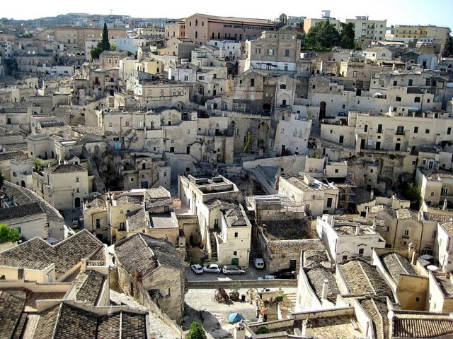
Matera was built above a deep ravine, that divides the territory into two areas.  Matera was built such that it is hidden, but made it difficult to provide water supply to its inhabitants.  Early dwellers invested tremendous energy in building cisterns and systems of water channels.


The largest cistern has been found under PIAZZA VITTORIO VENETO, with its solid pillars carved from the rock and a vault height of more than 15metres it is a veritable Water Cathedral, which is navigable by boat.  Like other cisterns in the town, many of these cisterns were turned into houses and other kinds of water-harvesting systems were realized.  Some of these more recent facilities have the shape of houses submerged in the earth.


The TRAMONTANO CASTLE, begun in the early 16th century, is probably the only other structure that is above ground and of any great significance outside the Sassi.  However, the construction remained unfinished after Count Gian Carlo Tramontano’s assassination in the riot of the 29th of December, 1514.  It has three large towers, while 12 were probably included in the original design.  During some restoration work in the main square of the town, workers cane across what was believed to be the main footings of another Castle tower.  However, on further excavation, large Roman cisterns were unearthed.  Whole house structures were discovered where one can see how the people of that era lived.  Found under the main square was a large underground reservoir, complete with columns and a vaulted ceiling.

Because of the ancient primeval-looking scenery in and around the Sassi, it has been used by filmmakers (as the setting for ancient Jerusalem).  Some of the following famous Biblical period motion pictures were filmed in Matera : (1964) The Gospel According To Saint Matthew.—- (1985) King David. —-  (2004) The Passion of the Christ. —— (2005)  Mary.  —– (2006) The Nativity Story.

Acoma Pueblo

Acoma Pueblo


ACOMA PUEBLO is a native American Pueblo.  The word “pueblo” is the Spanish word for “town” or “village”.  It comes from the Latin root “populus”.  The Word “Acoma” is from the Acoma word ACOMA or ACU which means “the place that always was” or “people of the white rock”.

Acoma Pueblo is approximately 97km west of Albuquerque, New Mexico.  The historical land of Acoma Pueblo totalled roughly 5,000,000 acres and the Acoma have continuously occupied the area for more than 800years, making it one of the oldest continuously inhabited communities in the United States.


Acoma Pueblo scenery

The Pueblo lies on a 365ft MESA.  The isolation and location of the Pueblo has sheltered the community for more than 1,200years, which sought to avoid conflict with neighbouring Navajos and Apaches.  Francisco Vazquez de Coronado’s expedition (in 1540) described the Pueblo as “one of the strongest places we have seen”.  Upon visiting the Pueblo, the expedition “repented having gone up to the place”.  The only access to the Acoma Pueblo, during this time, was a set of almost vertical stairs cut into the rock face.

Today about 300 two and three-storey abode buildings are on the Mess with exterior ladders used to access the upper levels where residents live.  Access to the Mesa is by a road blasted into the rock face during the 1950s.  Approximately 30 or so people live permanently on the Mesa, with the population increasing on the weekends as family members come to visit and tourists, some 55,000 annually.

Acoma Pueblo streets


Acoma Pueblo has no electricity, running water or sewage disposal.  A reservation surrounding the Mesa, totalling 1,600 sq.km.  Tribal members live both on the reservation and outside it.  Contemporary Acoma culture remains relatively closed, however.  According to the 2000 Us census, 4,989 people identify as Acoma.

The buildings here are constructed  from abode bricks with beams across the roof that were covered with poles, brush and then plaster.  The roof of one level would serve as a floor for another.  Each level is connected to others by ladders serving as a unique defensive aid.  The ladders are the only way to enter the buildings, as the traditional designs have no windows or doors.  The lower levels were used for storage.  Baking ovens are outside the buildings, with water being collected from two natural cisterns.  The Acoma also has 7 rectangular KIVAS and a village Plaza which serves as the spiritual centre for the village.

Acoma Pueblo houses


Before contact with the Spanish, Acoma people ate corn, beans and squash, primarily .  MUT-TZE-NEE was a popular thin corn bread.  They also raised turkeys.  They hunted deer, rabbits and antelope.  Wild seeds, berries, nuts and other foods were gathered.  After 1700, new foods are noted in the historical record.  Pudding, corn mush, corn balls, wheat cake, peach-bark drink, flour bread, wild berries and prickly pear all became staples.  After contact with the Spanish, goats, horses, sheep and donkeys were raised.

In contemporary Acoma, other foods are also popular such as apple pastries, corn tamales, green-chilli stew with lamb, fresh corn and wheat pudding with brown sugar.
Irrigation techniques such as dams and terraces were used for agricultural purposes.  Farming tools were made of wood and stone and harvested corn would be ground with hand and mortar. Today, the Acoma produce a variety of goods for economic benefit.  Agriculturally they grow alfalfa, oats, wheat, chillies, corn, melon, vegetables and fruit.  They raise cattle and have natural reserves of gas, geo-thermal and coal resources.  Uranium mines, in the area, provided work for the Acoma, until their closings in the 1980s, after that, the tribe has provided most employment opportunities, however, high unemployment rates trouble the Pueblo.  The legacy of the uranium mines has left radiation pollution, causing the tribal fishing lake to be drained and some health problems within the community.

Acoma Pueblo pottery


Tourism is a major source of income for the tribe.  In 2008, Pueblo opened the Sky City Cultural Centre & Haak’u Museum at the base of the Mesa, replacing the original which was destroyed by fire in 2000.  Films about Acoma culture are shown and a café serves traditional foods.  The complex is fire-resistant, unlike traditional Pueblos, and they are painted light pink and purple, to match the landscape surrounding it.  Traditional artwork is exhibited and demonstrated at the centre, including ceramic chimneys crafted on the rooftops.  Arts and crafts also bring income into the community.


Acoma Pueblo women


The Acoma Pueblo has a Casino and a Hotel, the Sky City Casino Hotel which are alcohol-free and it is maintained by Acoma Business Enterprises, which oversees most Acoma businesses.  Acoma Pueblo is open to the public by guided tours for most of the year.  Photography of the Pueblo and the surrounding land is restricted.  Tours and Camera permits are purchased at the Sky City Cultural Centre, while photography may be produced, with permit.  Video recordings, drawings and sketching are prohibited.

Murad – Janjira Fort

Janjira Fort

MURUD – JANJIRA is the local name for a fort, situated on an island just off the coastal village of Murud, in the Raigad District of Maharashtra, India.

The word JANJIRA is not native to India and may have originated after the Arabic word JAZEERA (Island). Murud was once known in Marathi as HABSAN (of HABSHI or ABYSSINIAN). The name of the fort is a concatenation of the Konkani and Arabic words for “island” (MOROD and JAZEERA). The word MOROD is peculiar to Konkani and is absent in Marathi.  
Janjira Fort
Murud – Janjira Fort is situated on an oval-shaped rock (instead of the “oblong” and “square-shape”) off the Arabian Sea coast near the port town of Murud, 165km south of Mumbai. Janjira is considered one of the strongest marine forts in India. The fort is approached by sailboats from Rajapuri Jetty.
Janjira FortThe fort has 26 rounded bastions. Now in ruins, the fort in its heyday was a full-fledged living fort with all the necessary facilities —— palaces, quarters for officers, mosque, two small 60ft-deep natural fresh water lakes. On the outer wall flanking the main gate, there is a sculpture depicting a tiger-like beast clasping elephants in its claws. The four elephants symbolize Shivaji’s major enemy dynasties on which he possessed control, whereas he tiger-like beast symbolizes control of Shivaji on these. There are prominent Ashoka Chakras on all the major gates of Janjira Fort.
Janjira Fort
A special attraction of this fort are three gigantic cannons named KALALBANGDI, CHAVRI & LANDA KASAM. These cannons were said to be feared for their shooting range. Another gate to the west is sea-facing, called the DARYA DARWAZA.

There is also another fortress, named GHOSALGAD, which is located on top of the hill around 32km east of Murud – Janjira, that was used as a outpost for the rulers of Janjira.

Janjira fort, built at the end of the 17th century, is almost entirely intact even today, despite the ravages of wind and tide, a testimony to the marvels of ancient engineering. According to all accounts, the JAL – DURK (Sea Fort) could not be conquered by any of the Kings ruling the neighbouring territories. Surprisingly, not even Shivaji could acquire the fort despite 13 expeditions to conquer the fort. His son, Sambhaji, tried a unique approach to capture the fort : digging an underwater tunnel to enter. But, he too failed in his attempt. Not to be deterred, Sambhaji constructed another fort just across the bay, called KANSA. Most of the earth that was dug up to build the tunnel was used in the making of this 2nd fort, which was to be the base for future attacks on the Sea Fort of Janjira. It took 22years to build Kansa, and it is constructed on 22acres of land.
Visitors can gain access to the Janjira Fort from Rajapuri. The fort wall is about 40ft high and has 19 rounded porches or arches, some of which still have cannons mounted on them. Inside the fort walls, the ruins of a mosque, a palace and bath with water channelled from streams, tell of ancient times when royal ladies occupied the quarters. The deep well with cold and sweet water —- a wonder of nature in the midst of the saline sea, still provides water to quench the thirst of the weary visitor. This invincible fort remained unconquered until it became part of the Indian Territory after Independence from the British in 1947. 

Umaid Bhawan palace

Umaid Bhavan Palace


UMAID BHAWAN PALACE, located at Jodhpur in Rajasthan, India, is one of the world’s largest private residences.  A part of the Palace is managed by Taj Hotels.  Another part of the palace houses a museum.

It was called CHITTAR PALACE, during its construction, due to use of stones drawn from the CHITTAR HILL where it is located.  Ground for the foundation of the building was broken on the 18th of November, 1929 by Maharaja Umaid Singh and the construction was completed in 1943.  The Palace was built to provide employment to thousands of people during the time of famine.


 Umaid Bhavan Palace

The history of the building is linked to a curse by a Saint who had said that a period would follow the good rule of the Rathore Dynasty.  Thus, after the end of about the fifty- year-reign of Pratap Singh, Jodhpur faced a severe  drought and famine condition in the 1920s for a period of three consecutive years.  The farmers of the area, faced with famine, sought the help of the then King Umaid Singh, who was the 37th Rathore Ruler of Marwar at Jodhpur, to provide them with some employment so that they could survive.

The King decided to build a lavish Palace.  He commissioned Henry Vaughan Lanches, who was a contemporary of Sir Edwin Lutyens, who planned the buildings of the New Delhi Government Complex, by adopting the themes of domes and columns.  The Palace was designed as an extraordinary blend of Western technology and many Indian architectural features.  About 2,000 – 3,000 people were employed.  However, the actual occupation of the Palace by the Maharaja came only after its completion in 1943, very close to the period of India’s Independence.

Umaid Bhavan Palace


The site chosen was on Chittar Hill, in the outer limits of Jodhpur, where no water supply was available nearby and hardly any vegetation grew, as the hill slopes were rocky.  The building material (from sandstone quarries) required were quite a distance.  The Maharaja built a railway line to the quarry site to transport the building material.  Donkeys were inducted to haul soil to the site.  The sandstone transported was dressed at the site into large blocks with interlocking joints, so that they could be laid without the use of mortar and thus create a wonderful edifice.

The Palace was built with dun-coloured (golden-yellow) sandstone with two wings in an area of 26acres of land, including 15 acres of well-tended gardens.  The interior central dome sits above a sky-blue inner dome.  The inner vaulted dome rises to a height of 103ft in the interior part, which is capped by an outer dome of 43ft height.  Makrana marble has also been used, and Burmese teakwood has ben used for the interior woodwork.  When completed, the Palace had 347 rooms, several courtyards and a large Banquet Hall which could accommodate 300 people.  The architectural style is considered as representing the then in vogue BEAUX Arts Style, also known as INDO-DECO Style.  However, for many years, the Palace did not function fully on account of many tragic events in the Royal family.  Umaid Singh, who stayed in the palace for only four years, died in 1947.  Hanumant Singh who succeeded him also died at a young age  ——- he had just won in the 1952 General Elections and was returning after this win, when his plane crashed and he died.  Gaj Singh –II, who succeeded his father, then decided in 1971 to convert a part of the Palace into a Hotel.

Umaid Bhavan Palace


The Hotel wing of the Palace is run by the Taj Group of Hotels.  It has 79 guest rooms, including the luxurious Regal and Vice Regal Suites and the fabulous “Maharaja” & “Maharani” suites, and the latter is fitted with a bath-tub that is carved from a single block of pink marble, said to be the only one of its kind in India.  The Maharani suite has a parquet flooring and a terrace.  The bedroom has an attached kitchen and the furnishing here is in pink and peach colours.  The bed is also fitted with an art feature of a woman sitting on a lion.  The Maharaja suits has furnishings in leopard skin and black marble flooring and a curved mirror dome.  Both the suites are decorated with murals.  The Banquet Hall of the Palace now forms a large restaurant.


Umaid Bhavan Palace


The Museum has exhibits of stuffed leopards, a very large symbolic flag, gifted to Maharaja Jaswant Singh by Queen Victoria in 1877, an impressive “quirky” collection of clocks in windmill and lighthouse shapes and photographs of the elegant art-deco interior of the palace.  The Classic cars of the Maharajas are also on display in the garden in front of the Museum.  Glass, porcelain ware, memorabilia and information on the building of the Palace are also part of the exhibits.


Umaid Bhavan Palace


The Darbar Hall, which is part of the Museum, has elegant murals and a substantial number of miniature paintings, armour and an unusual collection of household paraphernalia that was in vogue in the 1930s, which were costly and then not found in India.

October to March, during the winter season, are the best months to visit the Palace and the Museum.

Craiova

Craiova


CRAIOVA (KRA’YOVA) (Romanian pronunciation : KRAJOVA).  There are possible etymology for CRAIOVA : Old Slav KRAL (King), which has been borrowed in Romania as CRAI and Slav KRAJINA (border or edge)Since no source prior to 1475 mentions the city, it is impossible to tell which of the two words is the real etymology.  The name is probably of Bulgarian or Siberian origin, due to historical minorities in the area.


Craiova bridge


CRAIOVA is Romania’s 6th largest city and Capital of DOLJ County, and is situated near the east bank of the River JIU in Central OLTENIA.  It is a longstanding political centre and is located at approximately equal distances from the Southern Carpathians (north) and the River Danube (south).  CRAIOVA is the chief commercial city west of Bucharest and the most important city of OLTENIA.  The city prospered as a regional trading centre despite an earthquake in 1790, a plague in 1795 and a Turkish assault in 1802 during which it was burned.


Craiova park


In the first two decades of the 19th century, Craiova was characterized by economical growth, multiplication of its habitants’ pre-occupations in the areas of trade, commerce and public services.  In comparison with other great urban centres, Craiova is situated as a commercial, administrative and cultural knot of prime order.  In 1832, there were a number of 595 shops, of which “187 of wood and 398 of stone wall”.  It was exporting to Austria and Turkey ——- cereal, skins, wax, animals, tallow and cervices.  In 1846, the first Romanian Society on Shareholders for cereal transport by ship on the Danube was established.


Craiova fountain


Around 1860, there were 4633 buildings, of which 3220 were houses, 26 Churches, 11 schools, 60 factory-workshops.  There were also approximately 90 establishments with an industrial character of which : 12 windmills, 3 beer factories, 2 gas and oil factories, 4 tanneries and 2 printing units.  Craiova was a city that had small factories and workshops with chemical products, agricultural machines, graphics art, textiles, tanneries and construction materials.


Craiova cathedral


CATEDRALA STANTULUI DUMITRU ( Saint Demetrius Cathedral) is a Romanian Orthodox Cathedral.  There was likely a Church on the site by the 1490s, renovated in 1651 and having fallen into disrepair, demolished in 1889.  That year, work on a new Church began, and this was completed and sanctified in 1933.  The earlier Church’s proximity to the headquarters of the  BAN od Craiova, gave it importance in the city’s political life, as well as a defensive purpose, while the modern building’s role ensures its continued significance.


Craiova


NICOLAE ROMANESCU PARK ( formerly BIBESCU PARK) is the largest and most well-known park in Craiova.  Plans for the Park were awarded the Gold Medal at the 1900 World Fair.  Work began in 1901 and was completed in 1903.

GRADINA BOTANICA din CRAIOVA (Botanical Garden) is a scientific organization, where plant specimens are collected from different regions of the country and preserved as reference material, but also as study material for the students of University of Craiova.  The garden occupies a large area in the centre of the city, covering an area delimited by streets and at an altitude of about 99metres.  It is also referred to as a local park for the citizens of Craiova and a tourist destination.

Craiova University


CASA BANIEI : the Ethnographic Museum of Craiova is located in the historic city centre and is located in the town park.  The building, known as CASA BANIEI, is one of the oldest, non-religious monuments of medieval architecture in Craiova.  It was built in the 15th century, but was partially destroyed.  In 1699, it was restored by Prince Constantin Brancoveanu.  From the original building, there are preserved only the underground parts with arched brick walls.  Over the years, CASA BANIEI re-purposed repeatedly, but since 1966, it houses the ethnographic collection of the Museum of Oltenia.  Among the exposures, there can be seen restorations of household articles with the characteristic region pottery, textiles, costumes, musical instruments and ritual objects.  There are organised puppet shows and workshops for children in the building, as there is housed the first Museum of Puppet Theatre in Oltenia.

Yonaguni monument

Yonaguni monument


YONAGUNI MONUMENT ( submerged site in Japan), also known as YONAGUNI (Island) SUBMARINE RUINS, refers to one of the largest features within a submerged rock formation off the coast of YONAGUNI, the southernmost of the RYUKYU Islands in Japan.

Masaaki Kimura. Professor Emeritus from the Faculty of Science at the University of the Ryukyu claim that the formations are man-made stepped monoliths.  His ideas are disputed and there is debate about whether the site is completely natural, a natural site that has been modified or a man-made artefact.

Yonaguni monument


The sea of YONAGUNI is a popular diving location during the winter months, due to its large population of hammerhead sharks.  In `1987, while looking for a good place to observe the sharks, Kihachiro Aratake, a Director of the YONAGUNI – CHO Tourism Association, noticed some singular seabed formations resembling Architectonic Structures.  Shortly thereafter, a group of scientists, directed by Masaaki Kimura, visited the formations.

The formation has since become a relatively popular attraction for divers and instructors, despite the strong currents.  In 1997, Japanese Industrialist, YASUO WATANABE sponsored an informal expedition comprising writers John Anthony West and Graham Hancock, photographer Santa Faiia, geologist Robert Schoch, a few sport divers and instructors and a film crew for Channel – 4 and Discovery Channel.  Another notable visitor was free diver Jacques Mayol, who wrote a book on his dives at YONAGUNI.

Yonaguni monument


The Monument consists of medium to very fine sandstones and mudstones of the Lower Miocene Yaeyama Group believed to have been deposited about 20million years ago.  Most of the formations are connected to the underlying “rock mass” as opposed to being assembled out of free-standing rocks.

The main feature (the Monument Proper) is a rectangular formation measuring about 490 x 130ft, and about 90ft tall, and the top is about 16ft below sea level. Some of its details are said to be :
* 2 closely-spaced pillars which rise to within 8ft of the surface.
* A 16ft-wide ledge that encircles the base of the formation on 3 sides.
* A stone column about 23ft tall.
* A straight wall, 33ft long.
* An isolated boulder resting on a low platform.
* A low star-shaped platform.
* A triangular depression with 2 large holes at its edge.
* A L-shaped rock.
YONAGUNI lies in as earthquake-prone region and such earthquakes tend to fracture the rocks in a regular manner.  On the northeast coast of YONAGUNI, there are regular formations, similar to those seen at the Monument.  John Anthony West suggests the  “walls” are simply natural horizontal platforms that fell into a vertical position, when rock below them eroded and the alleged roads are simply channels in the rock.
The existence of an ancient stone-working tradition at YONAGUNI & other RYUKYU Islands is demonstrated by some old tombs, and several stone vessels of uncertain age.  Small camps, pottery, stone tools and large fireplaces, were found on YONAGUNI, possibly dating back to 250 BCE.  However, Archaeologist Richard J. Pearson notes that these were small communities, adding, “They are not likely to have had extra energy for building stone monuments.

Yonaguni momument


The flat parallel faces, sharp edges and mostly right-angles of the formation have led some to conclude that the features are man-made.  These features include a “trench”, that has two internal 90degree angles, as well as the twin megaliths that, according to Kimura, appear to have been placed there.  These megaliths have straight edges and square corners, however, sea currents have been known to move large rocks on a regular basis.  Some of those who see the formations as being largely natural, claim that they may have been modified by human hands.

Other evidence, presented by those who favour an artificial origin, include the two round holes (about 2ft wide) on the edge of the Triangle Pool feature, and a straight row of smaller holes that have been interpreted as an abandoned attempt to split off a section of the rock by means of wedges, found in ancient quarries.  Kimura believes, he had identified traces of animal drawing and people engraved into the rocks, including a “horse-like” sign, he believes resembles a character from the KAIDA SCRIPT.  Some have also interpreted a formation, on the side of one of the monuments, as a crude mole-like face.

Yonaguni monument


Kimura first estimated that the monument must be at least 8,000BCE, dating it to a  period when it would have been “above water”.  In a report given to the Pacific Science Congress in 2007, he revised the estimate to 2,000 or 3,000 years ago, because the sea level then was close to current levels.  He suggests, that after construction, Tectonic Activity caused it to be submerged below sea level.  He believes he can identify a pyramid, castles, roads, monuments and a stadium.  Kimura also surmised that the site may be a remnant of the MYTHICAL LOST CONTINENT of MU.

Anazarbus

Anazarbus


ANAZARBUS was an ancient CILICIAN city, situated in ANATOLIA, in modern Turkey ( in Turkish : ANAVARZA), about 15km west of the mainstream of the present CEYHAN River (or classical PYRAMUS River) and near its tributary the SEMPAS SU.

A lofty isolated ridge formed its Acropolis.  Though some of the masonry in the ruins is certainly pre-Roman, its identification with CYINDA, famous as a treasure city in the wars of EUMENES of CARDIA, cannot be accepted in the face of STRABO’S express location of CYINDA in Western CILICIA.
It was founded by Assyrians.  Under the early Roman Empire, the place was known as CAESAREA, and was the metropolis of CILICIA SECUNDA.  It was the home of the poet OPPIAN.  Rebuilt by Emperor Justin -1, after an earthquake in the 6th century, it became JUSTINOPOLIS (525), but the old native name persisted, and when THOROS -1, King of Lesser Armenia, made it his capital early in the 12th century, it was known as ANAZARVA.

Anazarbus scenery


Its great natural strength and situation, not far from the mouth of SIS PASS and near the great road which debouched from the CILICIAN GATES, made ANAZARBUS play a considerable part in the struggles between the Byzantine Empire and the early Muslim invaders.  The MAMLUK Empire of Egypt destroyed the city in 1374.

The present wall of the lower city is of a late construction.  It encloses a mass of ruins conspicuous in which are a fine TRIUMPHAL ARCH, the Colonnades of two streets and a gymnasium.  A stadium and a theatre lie outside the walls to the south.  The remains of the Acropolis fortifications are very interesting, including the roads and ditches hewn in the rock, and there are the ruins of two churches and a gatehouse.  There are no notable structures in the upper town.  For picturesqueness the site is not equalled in CILICIA, and it is worthwhile to trace the three fine aqueducts to their sources.  A NECROPOLIS, on the escarpment to the south of the walls, can also be seen complete with signs of illegal modern excavations.

Anazarbus


A visit in December 2002, showed that the three aqueducts have been nearly completely destroyed.  Only small isolated sections are left standing with the largest portion lying in a pile of rubble that stretches the length of where the aqueducts once stood.  A powerful earthquake that struck the area in 1945 is thought to be responsible for the destruction.

A modest Turkish farming village (DILEKKAYA) lies to the southwest of the ancient city.  A small outdoor museum with some of the artefacts collected in the area can be viewed for a small fee.  Also nearby are some beautiful mosaics discovered in a farmer’s field.
ANAZARBUS / ANAVARZA was one of a chain of Armenian fortifications stretching through CILICIA.  SIS CASTLE lies to the north, while TUMLU KALE (TUMLU CASTLE) lies to the southwest and AMOUDA CASTLE lies to the southeast.

Mehrangarh Fort

Mehrangarh Fort


MEHRANGARH, located in Jodhpur, Rajasthan, is one of the largest forts in India.  Built around 1460 by RAO JODHA, the fort is situated 410ft above the city, and is enclosed by imposing thick walls.  Inside its boundaries, there are several Palaces known for their intricate carvings and expansive courtyards.  The imprints of cannonball hits, by attacking armies of Jodhpur, can still be seen on the second gate.


mehrangarh fort


MEHRANGARH : MIHIR (Sanskrit) Sun or Sun Deity and GARH (Sanskrit) Fort, thus SUN FORT, according to the Rajasthani language pronunciation conventions MIHIRGARH has changed to MEHRANGARH.  The Sun Deity has been the chief deity of the Rathore Dynasty.  Though the fort was originally started  in 1459, most of the fort, which stands today, dates from 1638 – 1678.  The fort is located at the centre of the city spreading over 5km on top of a high hill.  Its walls, which are up to 118ft high and 69ft wide, protect some of the most beautiful and historic palaces in Rajasthan.


mehrangarh fort Phool mahal


The brilliantly-crafted and decorated palaces include MOTI MAHAL (Pearl Palace), PHOOL MAHAL ( Flower Palace), SHEESH MAHAL ( Mirror Palace), SILEH KHANA and DAULAT KHANA.


mehrangarh fort Sheesh mahal


There are seven gates, which include JAYAPOL (meaning ‘Victory’), built by Maharaja Man Singh to commemorate his victories over Jaipur and Bikaner armies ; FATTEHPOL ( also meaning ‘Victory’) built by Maharaja Ajit Singh to mark the defeat of the Mughals.  The “palm imprints” upon these still attract much attention.


mehrangarh fort museum


The Museum in the MEHRANGARH Fort is one of the most well-stocked museums in Rajasthan.  In one section of the Museum, there is a selection of old Royal palanquins, including the elaborate domed gilt MAHADOL Palanquin, which was won in a battle from the Governor of Gujarat in 1730.  The Museum exhibits the heritage of the Rathores in arms, costumes, paintings and decorated period rooms.


mehrangarh fort museum


ELEPHANT’S HOWDAHS : The HOWDAHS were a kind of two-compartment wooden seat (mostly covered with gold and silver embossed sheets), which were fastened on to the elephant’s back.  The ‘front’ compartment, with more leg-space and a raised protective metal sheet was meant for Kings or Royalty and the ‘rear’ (smaller one) for a reliable bodyguard disguised as  ‘fly-whisk attendant’.


mehrangarh museum


PALANQUINS : were a popular means of travel and circumambulation for the ladies of the nobility, up to the second quarter of the 20th century.  They were also used by male nobility and royals on special occasions.


Akbar sword


ARMOURY : This gallery displays a rare collection of armour from every period in Jodhpur.  On display are sword hilts I jade, silver, rhino horn and ivory, shields studded with rubies, emeralds and pearls and guns with gold and silver work on the barrels.  The gallery also has on display the personal swords of many Emperors, among them the outstanding historical piece like the KHAANDA of RAO JODHA, weighing over 3kg, the sword of AKBAR the GREAT and the sword of TIMUR.


Mehrangarh fort painting


PAINTINGS : This gallery displays colours of Marwar – Jodhpur, the finest examples of Marwar painting.

The TURBAN GALLERY : in the MEHRANGARH Museum seeks to preserve, document and display the many types of TURBANS, once prevalent in Rajasthan.  Every community, region and festival had its own head-gear.

Chamunda Mataji temple


CHAMUNDA MATAJI TEMPLE, was Rao Jodha’s favourite Goddess.  He brought her idol from the old capital of MANDORE in 1460, and installed her in MEHRANGARH ( MAA CHAMUNDI was the KUL DEVI of the PARIHAR Rulers of MANDORE)  She remains the Maharaja’s and the Royal Family’s ISHT DEVI or ADOPTED GODDESS, and is worshipped by most of Jodhpur’s citizens as well.  Crowds throng MEHRANGARH during the DUSSEHRA celebrations.

CULTURE : The fort has musicians performing folk music at the entrance and it houses restaurants, exhibitions and craft bazaars.  The fort was one of the filming locations for the 2012 dark movie THE DARK KNIGHT RISES.  The scene where Christian Bale rises from the pit was shot here.
In 2015, the fort was used to record a collaborative album by musicians including Israeli composer — SHYE BEN TZUR, English composer and Radiohead guitarist —— Jonny Greenwood and Radiohead producer — Nigel Godrich.  The recording was the subject of a documentary —- JUNUN, by the American director Paul Thomas Andersen.  –